
The Maya Route: Mexico, Guatemala & Belize
At Palenque in Mexico, you stand outside the Temple of the Inscriptions, named for the hundreds of stone hieroglyphs that tell the city’s story. On Guatemala’s Lake Petén Itzá, you tour the ARCAS wildlife rescue center by boat. In Belize, you ride a hand-cranked ferry over the Mopan River to reach the Xunantunich pyramids.
West of the Riviera Maya, the Yucatan Peninsula stretches inland without a single surface river. Yucatec Maya farmers in this region cultivate their crops by relying entirely on subterranean water sources, accessing the deep swimming basins of Cenote Yokdzonot and the limestone cavern of Suytun. Further south in Chiapas and the Peten department, a thick broadleaf canopy covers the excavated plazas of Palenque and Tikal. To move through this region, local residents use the Usumacinta River to reach the border ruins of Yaxchilán, and operate a hand-cranked cable ferry to cross the Mopan River toward the temples of Xunantunich.
Across the eastern border in Belize, Caribbean pine trees grow around the Mountain Pine Ridge Reserve, where the Rio On Pools forms natural granite swimming basins. Leaving the highlands, the final days take place on the edge of the Belize Barrier Reef. Off the Quintana Roo coastline, local dive crews explore the shallow coral reefs and the underwater cave systems of Dos Ojos, trading the sound of inland howler monkeys for the break of the Atlantic surf.
Uxmal
Capital of the Puuc Region
Cenotes
Cool off in a crystal cave
Palenque
Royal Seat of King Pakal
Tulum
The Walled Caribbean Port
Mexico, Guatemala & Belize: Trip Highlights
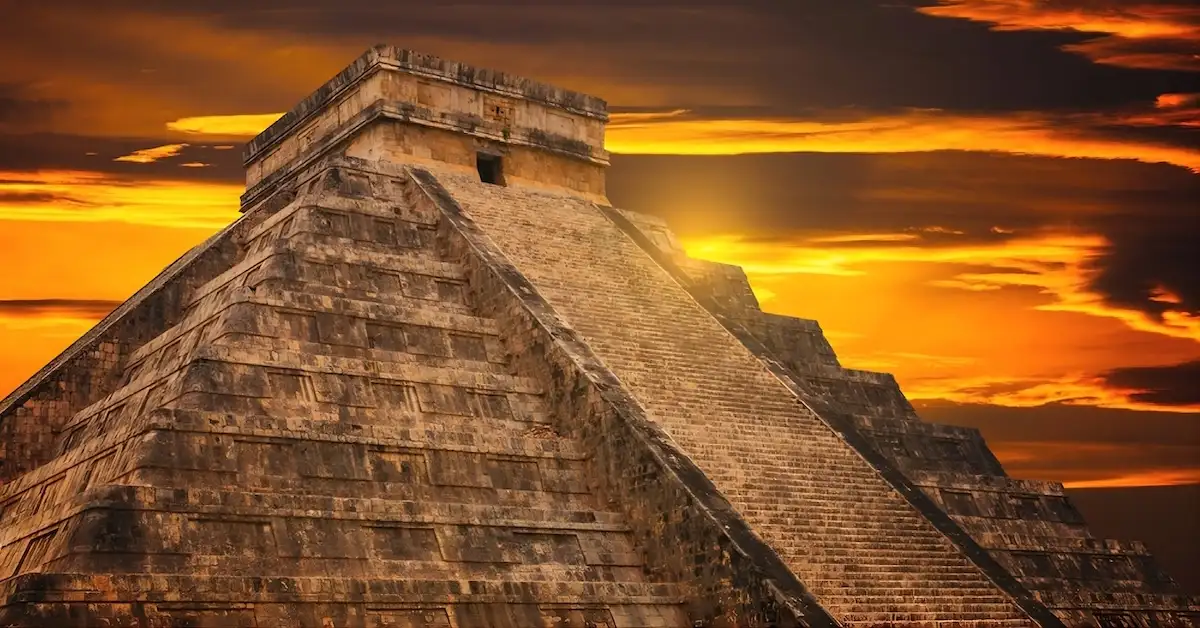
In the northern Yucatan, Chichen Itza and Uxmal showcase societies that engineered survival without rivers. Local guides explain how builders carved underground cisterns called chultunes into the limestone to capture seasonal rain. At Uxmal, Maya architects aligned the 98-meter facade of the Governor’s Palace to track the movements of Venus, while builders raised the 30-meter steps of El Castillo at Chichen Itza to serve as a physical solar calendar.
Crossing into Chiapas and Guatemala, the architecture shifts to match the rainforest. In Palenque, engineers channeled river water to run underground aqueducts beneath four-story observation towers. Deep inside the Peten basin, builders raised 40-meter temples to breach the tree canopy at Tikal, alongside Twin-Pyramid complexes constructed specifically to mark 20-year calendar cycles.
In Belize, the Maya viewed the 65-foot arched entrance of Rio Frio Cave as a physical portal to the underworld. Nearby, Caracol rulers orchestrated the military defeat of Tikal from the rooms of Caana, a 43-meter palace. Finally, on the Quintana Roo coastline, city leaders at the walled fortress of Tulum used the Temple of the Wind as an acoustic warning system for incoming hurricanes.
14-Day Mexico, Guatemala & Belize Itinerary
Day 1: Cancun Arrival
Upon landing at Cancun International Airport (CUN), a local driver waits in the arrivals hall to begin the transfer into the city. The drive covers 20 kilometers, taking about 30 minutes to reach a hotel in the Zona Hotelera (Hotel Zone) or the center of Cancun to rest before the overland expedition begins the following morning.
- One night in Cancun.
Day 2: Chichen Itza & The Yellow City of Izamal
The morning begins with a two-and-a-half-hour drive covering 200 kilometers to Chichen Itza. Stepping out at the main entrance, the heat of the Yucatan interior sets in. Beyond the visitor center, the Great Plaza serves as the central political space. In the middle stands El Castillo, a 30-meter step pyramid constructed as a physical solar calendar.
To the side, the Temple of the Jaguar served as a military command post. Moving west, rulers used the Great Ball Court to settle political disputes through high-stakes ritual games. Standing in the North Temple, you can hear how the acoustic engineering projects voices across the field, while the South Temple closes off the opposite end.
Just outside the court, the Tzompantli (a carved stone skull rack) rests in an open clearing, historically used to display the heads of defeated enemies. Nearby, priests hosted military ceremonies at the Platform of the Eagles and Jaguars, and tracked planetary movements from the Platform of Venus.
North along the white limestone path of Sacbe Number 1, the Sacred Cenote opens up in the trees. During severe droughts, priests threw jade and gold offerings into the water to appease the rain deity. South of the main plaza, the Temple of the Warriors displays Central Mexican Toltec designs. Unlike older Maya cities, the rulers here projected their military power by incorporating wide stone columns and feathered-serpent carvings directly into the architecture. Directly adjacent to this temple, city officials conducted daily business inside the Group of a Thousand Columns, a massive open-air administrative hall.
Further south, El Mercado served as the central hub for regional merchants. A short distance away, the Steam Bath contains stone rooms built for purification rituals, while the Osario served as a burial site for high-ranking priests, sitting above a deep natural cave.
In the southern residential sector, the Xtoloc Cenote provided everyday drinking water, bordered by the Xtoloc Temple. Down the dirt path, the House of the Corn Grinders and the House of the Deer provided functional spaces for preparing food and processing animal hides. The Red House stands just beyond, built as an elite private residence.
Further along, the circular stone tower of The Observatory allowed astronomers to track crop cycles. The southern edge of the site contains The Nunnery government palace, its Annex, and the Akab Dzib, concealing hidden hieroglyphic records. The afternoon concludes by buying cold coconuts or water from local vendors near the exit.
Following a 20-minute drive covering 20 kilometers, a local women’s cooperative manages Cenote Yokdzonot. A dirt trail cuts through low trees to the edge of the sinkhole. From the upper rim, a wooden staircase built against the rock descends to a water-level platform. Tree roots hang down from the surface edge into the main basin, providing a shaded place to swim before the hike back up the stairs.
Continuing the route 80 kilometers west requires roughly an hour and a half behind the wheel to reach Izamal. Locals paint all the city buildings entirely yellow. The walk begins at the Plaza de la Constitucion and Parque Itzamna.
Across the street rests the Convento de San Antonio de Padua, standing on top of a destroyed Maya base. In the 1500s, Franciscan friars built the atrium and the main church directly over the rubble to physically replace the Maya religious center. Walking a short distance through the streets brings you to the base of the Kinich Kak Moo Pyramid. Built to honor the sun, the foundation covers an entire city block. The size of this stone base makes it one of the largest pyramids by volume in Mexico. The structure was so massive that later Spanish settlers simply built the Izamal directly around its remaining stones.
Back at street level, the mounds of the Itzamatul, Kabul, and Habuk pyramids sit directly between modern homes. The afternoon wraps up by buying fresh fruit at the Mercado Municipal before riding the final 70 kilometers into Merida for the evening.
- One night in Merida.
Day 3: Uxmal, Kabah & The Walled City of Campeche
Leaving Merida, an 80-kilometer drive south takes about an hour and fifteen minutes. You drive out of the flat scrubland and up into the Puuc region, a series of limestone hills known for its highly detailed stone mosaic architecture. Inside the main entrance of Uxmal sit the Chultunes, underground cisterns built to catch rainwater during the dry season.
Just beyond lies the Plaza of the Birds, a courtyard used for early civic gatherings. Here stands the 35-meter Pyramid of the Magician. Unlike most stepped structures, builders constructed its base over five generations, resulting in a rounded, oval-shaped foundation. This curved design is entirely unique to Uxmal and does not appear in other major Maya sites. Behind it rests the Nunnery Quadrangle. Rulers used this four-building complex as a military academy and council house.
South of this courtyard, the Ball Court provided a physical arena where rulers settled political disputes through high-stakes games. Adjacent to the arena, the House of the Turtles contains a simple stone exterior carved specifically to honor the rain. Just beyond, the Governor’s Palace rests on a raised platform. The ruler Lord Chahk lived here, and Maya architects aligned the 98-meter facade with the path of Venus.
The Throne of the Jaguar sits in the plaza in front of the palace, used by the king for public addresses. Behind the palace, standing at the summit of the Great Pyramid provides a clear view across the entire city. To the west stands the Pigeon House, an administrative structure recognizable by its perforated stone roof comb.
Further south, elite families used the South Temple and Cemetery Group as burial and memorial sites. The Chanchimez Group and the House of the Old Woman stand nearby as early residential areas. Inside the Phallic Temple, stone carvings relate to fertility rituals, while local administrators governed from the Group of the Columns. At the far edge of the site stands The Arch, a freestanding stone gateway marking the beginning of the Sacbe (a raised white limestone road) connecting Uxmal directly to the neighboring ruins of Kabah.
Driving 20 kilometers from Uxmal takes about twenty minutes to reach Kabah. Inside the main entrance stands The Arch of Kabah. Following the Sacbe section into the clearing exposes the Great Temple, the primary religious center. Local rulers lived inside the Palace Group.
The main structure here is the Codz Poop. The entire front facade consists of 250 repeating stone masks of the rain deity Chaac. This absolute visual focus on the rain reflects Kabah’s strict dependence on seasonal storms, a sharp geographical contrast to the Maya cities built along the southern river basins. In front of this temple, carved inscriptions on the Altar of the Glyphs record the dynastic history of the city. A short distance away, the elite families of the city lived inside the private stone residences of the Manos Rojas complex.
Covering 140 kilometers from Kabah to Campeche takes about two hours. The air grows heavier approaching the Gulf of Mexico. The historical walk begins at the Plaza de la Independencia, the central hub for colonial administration. The Catedral de Campeche stands on the edge of the square, built by the Spanish in the 1500s.
Across the plaza, the Centro Cultural Casa Numero 6 preserves the exact interior of an 18th-century merchant mansion, complete with imported European furniture and an interior courtyard that shows the immense wealth generated by the port. Down the street, the pastel-painted facades of Calle 59 stretch westward toward the Puerta de Mar, the original stone sea gate where those imported goods first entered the fortified city.
Following the old defensive wall, the Baluarte de la Soledad and Baluarte de San Carlos (stone defensive bastions) sit facing the water, built specifically to repel pirate attacks. Inland, the Puerta de Tierra (Land Gate) served as the heavily fortified landward entrance. The Baluarte de San Juan, Baluarte de San Francisco, and Baluarte de Santa Rosa complete the defensive ring, historically used to store gunpowder. The day ends on the Malecon (the waterfront promenade), watching fishing boats return to the harbor along the Gulf of Mexico.
- One night in Campeche.
Day 4: Edzná Archaeological Zone & The Chiapas Jungle Route
Leaving Campeche in the morning, a 50-kilometer drive inland takes roughly fifty minutes to reach the Edzná Archaeological Zone. Following the dirt path past the main entrance, you enter the Patio of the Ambassadors, where visiting foreign dignitaries rested before meeting the city’s rulers. Directly adjacent, priests performed ceremonial offerings at the Platform of the Knives (Structure 409), a long stone base where archaeologists excavated hundreds of sharp blades carved from obsidian (dark volcanic glass) and flint (a hard, gray stone used for cutting).
The route continues into The Main Plaza, an expansive open clearing that served as the primary civic gathering space. Bordering the western edge is Nohoch Na (The Great House), a massive 135-meter-long stone gallery featuring multiple entrances where city administrators collected tributes (goods and agricultural taxes paid by the population) and watched public ceremonies. Opposite this structure, nobility settled political disputes inside the stone arena of The Ball Court (Structure 420). At the southern end of the square, priests performed elite rituals inside the vaulted rooms (stone chambers built with high, arched ceilings) of the South Temple (Structure 419).
Moving further south, the path enters The Old Plaza, the original commercial core of the city. Priests worshipped the sun deity at the Temple of the Masks (Structure 414), where two large plaster faces sculpted onto the wall represent the morning and evening sun. Directly adjacent, local leaders managed neighborhood affairs from The Small Acropolis (Structure 416), a raised square platform supporting four stone buildings. Within this complex, city officials recorded the history and conquests of the kings on the carved stone monuments inside the Temple of the Stela (named after the tall, upright carved stones the Maya used to document history), while the king’s family used the South Structure of the Small Acropolis for private meetings.
Returning north, the walking trail reaches The Great Acropolis, a massive elevated platform built to lift the royal compound above the surrounding valley floor. Rulers carved dynastic records (the historical timeline of the city’s kings) directly into the stone steps of the Hieroglyphic Stairway, which leads up to the Central Courtyard. In the exact center of this high plaza, priests placed offerings on the Radial Platform, a square altar featuring staircases on all four sides.
Dominating the eastern edge is the Building of the Five Stories (Structure 411). Unlike standard solid pyramids found at other Maya ruins, the main 31-meter pyramid here uniquely functions as a multi-story palace containing accessible stone rooms on every single level. Furthermore, what separates Edzná from all other ancient cities on this itinerary is its vast hydraulic network (an advanced water management system), where the local population dug over 13 kilometers of wide canals to drain the valley during heavy rains and store freshwater for the dry season.
Bordering the southern edge of this courtyard, the royal family used the House of the Moon (South Building) for private night-time rituals. Across the plaza, the North Temple marks the northern edge of the square. On the western corners, priests used the Southwest Temple and Northwest Temple for smaller religious gatherings. Tucked behind these main structures, the ruling elite decorated the stone walls of the Puuc Patio and the Puuc Annex—named after a regional architectural style famous for its highly detailed stone mosaics.
Looking outward from the high platforms, merchants traveled along Sacbé 1 (a raised white limestone road) to transport goods out to regional trade routes. About 800 meters to the northwest, city guards used The Old Sorceress Group as a distant lookout tower and shrine. To the south, military forces defended the city perimeter from The Fortress Group, a raised stone complex built on high ground to monitor approaching visitors.
After completing the historical walk, the overland journey resumes. Covering the remaining 310 kilometers to Palenque takes about four and a half hours, driving inland away from the Gulf coast and entering the state of Chiapas to check into a hotel for the evening.
- Two nights in Palenque.
Day 5: Palenque, City of Water & Misol-Ha
The morning begins with a fifteen-minute drive from the Palenque town center to the archaeological zone. Past the main entrance, the first structures sit at the base of the hills. Here stands the Temple of the Skull, a stone platform where early rulers displayed the heads of defeated enemies to establish dominance. Adjacent to it rests the Tomb of the Red Queen. Inside, archaeologists discovered a queen covered completely in toxic cinnabar (a crushed red mineral), a burial practice that stained her remains a bright red.
Just past the Tomb of the Red Queen, the Temple of the Inscriptions serves a dual purpose: hiding the massive stone tomb of King Pakal deep inside its base, while displaying his royal bloodline on carved stone panels at the summit. Across the main courtyard, city officials managed daily administration from the stone corridors and residential rooms of The Palace. In the center, priests climbed the four-story Observation Tower to track the winter solstice.
Beneath these courtyards, the Baños de la Reina (Queen’s Baths) reveal how the royal family controlled the Otolum River. Unlike flat lowland cities that relied entirely on standing rainwater pools, the rulers of Palenque captured the steep mountain streams, funneling the rushing water through underground stone aqueducts directly into the palace complex.
Walking across this river takes you to the Cross Group. King K’inich Kan Bahlam II built this triad of step-pyramids—the Temple of the Cross, the Temple of the Sun, and the Temple of the Foliated Cross—specifically to legitimize his right to rule following the death of his famous father. Further south, the South Acropolis contains Temple XIX and Temple XXI. Here, archaeologists found large stone panels showing later kings performing blood sacrifices.
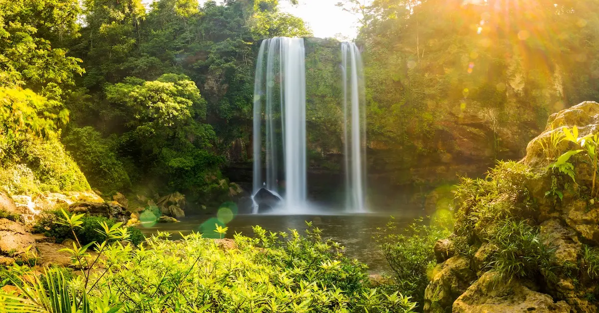
The visit ends at the Site Museum, which holds a precise replica of King Pakal’s jade mosaic death mask. Leaving the ruins, a 20-kilometer drive takes thirty minutes to reach Misol-Ha, a 35-meter waterfall that drops into a deep circular pool. Local workers carved a stone pathway directly behind the water curtain, providing access into the damp cave that feeds the spring. The afternoon concludes near the water, where a local cooperative sells Chiapas-grown coffee before the return drive to the hotel.
Day 6: Lake Petén Itzá, Flores Island & Tayasal Ruins
Riding 330 kilometers overland from Palenque into the Petén Department of Guatemala takes about six hours. The route continues south to the border crossing at El Ceibo to clear customs and switch to a Guatemalan vehicle before reaching the lakeside town of Flores. Arriving at the water, the vehicle crosses one of the stone causeways—raised land bridges connecting the island directly to the mainland towns of Santa Elena and San Benito.
The walking tour of Flores begins on foot along Calle Centro América and Calle 10 de Noviembre, two primary commercial streets lined with brightly painted colonial buildings and small artisan shops selling local crafts. Following the cobblestone streets uphill leads to Plaza Central (Parque Central) at the highest point of the island. Here, the white-walled Nuestra Señora de los Remedios Cathedral stands directly over the foundations of a destroyed Itzá Maya temple.
Along the upper historic streets, old metal public payphones remain mounted on corner walls as preserved curiosities from the pre-cellular era. Descending the northern slope, the route passes the island basketball court and waterfront amphitheater, where local families gather for community events. Near the water’s edge, travelers pause at the brightly painted “Yo Amo Petén” sign for photographs before reaching The Malecon, the perimeter boardwalk and dock road surrounding the island.
At the Malecon docks, you board a covered wooden motorboat to begin navigating Lake Petén Itzá. Looking back toward the shore provides a clear view of the Santa Elena and San Benito causeways anchoring the island to the mainland. The wooden boat heads north across the open water toward the indigenous waterfront village of San Miguel.
Just off the shoreline rests the Monument to the Stone Horse. Local history records that when Spanish explorer Hernán Cortés passed through the region in 1525, he left behind an injured horse. The Itzá Maya treated the unfamiliar animal as a deity, feeding it meat and flowers. When it died, the island residents carved a stone statue named Tzimin Chac (Thunder Horse) to appease their deities.
Continuing east along the shoreline, the boat passes the ARCAS Wildlife Rescue Center, where conservationists rehabilitate native animals like spider monkeys, toucans, and parrots rescued from illegal trade. The route continues past the Petencito Zoo islets—small forested islands linked by wooden hanging bridges—before curving into La Guitarra Lagoon, a quiet bay shaped like the body of a guitar. Across the open water, you can see the distant waterfronts of San José and San Andrés, two traditional Maya communities along the northern hills.
Cruising back along the eastern shore, the boat passes Jorge’s Rope Swing, a popular lakeside swimming spot, and the turquoise waters and wooden piers of Playa Chechenal eco-beach. The boat docks briefly at Islote Santa Bárbara, a tiny island home to the Museo Regional del Mundo Maya. Inside the building, display cases show ancient ceramic vessels, sharp cutting tools carved from flint (a hard, gray stone used by the Maya to make weapons and blades), and carved jade artifacts recovered directly from the lake floor.
Leaving the museum island, the traditional wooden boat crosses the lake to the shore of the Tayasal Peninsula. The Itzá Maya used this heavily forested point as their center of power. Unlike the ancient cities of Tikal or Palenque that were abandoned centuries earlier, Tayasal is entirely unique because it remained a fully active, independent Maya capital until 1697. This makes it the absolute last Maya kingdom in the Americas to fall to Spanish conquerors, surviving almost two hundred years longer than the rest of the region. Stepping onto the dock, the dirt trail leads past deep pre-Columbian defensive trenches and earthworks—wide ditches and high walls of packed dirt dug by ancient warriors to block invading infantry.
The trail winds beneath giant Ceiba trees, massive rainforest trees with broad, winged roots that the Maya held sacred as physical pillars connecting the earth to the heavens. Further up the ridge, the walk passes the San Bernabé archaeological ruins and active excavation dig zones, where archaeologists work to clear moss and soil from exposed stone staircases and walls.
The path passes the Central Acropolis—a group of ancient stone buildings still completely buried under hills of dirt and jungle vines—before reaching the base of El Mirador del Lago (Pyramid T142, also known as the Rey Canek Lookout). Climbing the steep stone staircase leads to the summit, providing a 360-degree view across Lake Petén Itzá, the rooftops of Flores Island, and the surrounding jungle canopy.
Returning to the boat, the ride back to Flores begins as dusk approaches. The day ends on the open rooftop terraces of the island, watching the sun drop behind the western lake basin.
- Three nights in Flores Island.
Day 7: The Jungle Pyramids of Tikal
Driving 65 kilometers from Flores to Tikal takes roughly an hour and a half. The walk begins at the visitor center, continuing past the main gate. Just inside the entrance stands a giant Ceiba tree (the sacred tree of the ancient Maya), marking the start of the shaded dirt trails into the city.
The first major structures along the path are the Twin-Pyramid Complexes Q, R, O, and P. Rulers built these identical facing pyramids to commemorate the end of a K’atun (a 20-year Maya time cycle). Just west of here sits Maler’s Palace, containing the original private residences of the city’s nobility.
Past the trees, the Great Plaza served as the historical political center of the city. To the east, Maya architects built Temple I to hold the tomb of ruler Jasaw Chan K’awiil I. Facing it, they raised Temple II to honor his wife. To the north, the royal family used the North Acropolis as a cemetery for over 400 years, while local rulers governed from the administrative palaces inside the Central Acropolis to the south. At the edge of the plaza sit the Central and Triple Ball Courts, arenas where elites resolved disputes through high-stakes games.
Moving west, the Tozzer Causeway (a raised limestone road) connects the main plaza to Temple III, built specifically for the ruler Dark Sun. At the end of this route stands Temple IV. Reaching 65 meters tall, it is one of the absolute tallest surviving structures in the entire pre-Columbian Americas. Unlike the wider, flat pyramids found across the Yucatan Peninsula, Tikal stands out because of how incredibly steep and tall its monuments are. The royal family built Temple IV high enough to break entirely through the dense jungle canopy, creating a physical landmark visible across the entire basin. A wooden staircase accesses the summit, offering a clear line of sight to the stone roof combs (decorative stone crests) of the other temples rising above the tree canopy.
Below the temple, the Maudslay Causeway connects to Group H, an early stone neighborhood. From there, the Maler Causeway extends directly toward the East Acropolis and the Market Place, the historical commercial center where merchants traded jade, obsidian, and cacao.
Further south, builders designed the South Acropolis and the Plaza of the Seven Temples as a specialized complex containing three separate ball courts. Nearby is Mundo Perdido (Lost World), built by early astronomers to track the sun. Adjoining this observatory, architects constructed the Plaza of the Great Pyramid and Temple V. Architects designed this specific structure with unusual rounded corners and a massive, single continuous staircase leading to a one-room shrine, built specifically to house the tomb of an unknown king.
Finally, the Mendez Causeway reaches Temple VI. Here, carvers covered the roof comb with the longest carved text in the city, recording the history of the royal bloodline. The afternoon wraps up near the main entrance, listening to the howler monkeys in the trees before driving back to Flores.
Day 8: Yaxha & The Twin Lakes
Driving 70 kilometers from Flores to Yaxha takes about an hour and a half. Upon arrival, you enter the ancient city near the shores of the lake.
The first architectural group along the route is Plaza A. This area forms part of the North Acropolis, built originally as stone homes for the city’s elite families. Moving south, builders raised Plaza B and Plaza C. Rather than standard residential squares, these function as Twin Pyramid Complexes—massive open courtyards flanked by identical flat-topped pyramids facing each other from east to west. Mirroring the exact architectural style of nearby Tikal, residents used these specific spaces to celebrate the end of 20-year calendar cycles.
Just before Via 3 (a primary limestone road) is the Mesoamerican Ballcourt, a stone arena where the nobility played high-stakes ritual games. The end of this road marks the entrance to the Plaza Mayor. Inside this main square, early astronomers used the Astronomical Commemoration Complex to track the sun during the solstices.
Continuing along Via 5, local rulers governed city trade from the administrative courtyards of Plaza D and Plaza E. Past these squares, workers constructed the South Acropolis, a high-walled, multi-tiered complex raised on a natural ridge to isolate the king’s private residence from the rest of the city. Directly adjoining it rests the Plaza of the Shadows, a densely enclosed courtyard surrounded by steep stone walls that provided permanent shade during long royal ceremonies.
The final road, Via 6, ends at the East Acropolis. Here, Maya architects built Structure 216, also known as the Temple of the Red Stelae (carved upright stone monuments). As the tallest pyramid in the city, it was designed to rise completely above the surrounding jungle. Most Maya cities were built deep inside the jungle interior, but Yaxha is unique because of its direct physical connection to a massive lake. The raised limestone roads run straight from the high administrative plazas down to the water. Because of this deliberate height, the summit of the steep stone staircase has a clear line of sight over the tree canopy as the sun drops behind Lake Yaxha. At the base of the temple, the lakeside platforms face the water before the return drive to Flores.
Day 9: The Temples of Xunantunich & Cahal Pech
Leaving Flores in the morning, the 90-kilometer drive east to the Melchor de Mencos border takes about an hour and a half. After clearing customs and switching to a Belizean vehicle, the route continues into the Cayo District.
To reach the ancient city of Xunantunich, you board a hand-cranked wooden ferry to cross the Mopan River. On the opposite bank, the path follows a dirt incline up the limestone ridge to the main entrance. The first major areas are Plaza A-1 and Plaza A-2, expansive open courtyards designed specifically as civic centers where the general population gathered for public ceremonies.
Just past the Mesoamerican Ballcourt (a stone arena for high-stakes ritual games), builders laid out Plaza A-3 to anchor Structure A-6, commonly known as El Castillo. As one of the tallest structures in Belize, this massive pyramid functioned as the city’s primary temple. Artisans decorated its upper terraces with large plaster friezes (sculpted wall panels) displaying the faces of Maya deities.
While time and heavy rain eroded the exterior decorations at most other Maya sites, Xunantunich is distinct because these massive plaster sculptures remain completely intact, showing the exact details the royal family saw centuries ago. Because the pyramid rises completely above the tree line, its summit provides an unobstructed line of sight westward directly into Guatemala. Further down the ridge, laborers constructed Groups B, C, and D as restricted palace complexes, featuring private stone rooms and courtyards reserved strictly for the royal family and high priests.
Covering 12 kilometers from the river crossing, a 15-minute drive east reaches the town of San Ignacio. The vehicle climbs a steep hillside to enter Cahal Pech. Unlike the massive, open public plazas found at other Maya ruins, Cahal Pech is unique because it consists entirely of tightly packed, walled residential courtyards. Starting in Plaza A, the royal family held private ceremonies inside the Main Temples, positioned directly next to the stone playing surface of the Structure 1 Ballcourt. Adjoining this area, Plaza B functions as a highly restricted courtyard, specifically engineered with high walls to block visibility and prevent physical access from the lower classes.
At the heart of the estate is Structure B-4, the Royal Palace. Here, the layout consists of narrow stone sleeping quarters and audiencias (small reception galleries) where ruling families held private meetings. Expanding outward from this core, Plazas C through G consist of interconnected stone buildings used as administrative offices and housing for royal attendants. The historical walk concludes at the Royal Burial chambers, where archaeologists discovered high-status offerings of carved jade and volcanic obsidian, before the brief drive down the hill to the hotel in San Ignacio.
- Two nights in San Ignacio.
Day 10: Caracol, The Sky Palace & Mountain Pine Ridge
Leaving San Ignacio, the two-and-a-half-hour drive covers 80 kilometers of dirt logging roads deep into the Chiquibul Forest Reserve. The heavy broadleaf canopy overhead casts deep shade across the route before the trees part at the Caracol visitor center.
The main dirt path opens directly into Plaza A, leading straight to The Astronomical Observatory (Group A). The city’s priests utilized these specific stone alignments to track solar movements and dictate agricultural harvests. Past the grassy alley of the Main Ballcourt and the stone corridors of the Central Acropolis, the layout expands into Plaza B. Here stands Caana (Sky Palace). Wide stone steps lead up past the lower temples to reach the 43-meter summit.
The height of the Caana building makes Caracol physically stand out from other Maya ruins. Remaining the tallest man-made structure in modern-day Belize, the massive building functioned as a completely self-contained royal city. The rulers of Caracol utilized these highest rooms as their political epicenter, famously orchestrating the military defeat of rival Tikal in 562 AD from this exact vantage point.
The descent from the pyramid points south toward the South Acropolis (Group D) and the Barrio (Elite Residential Group), which contains the high-density sleeping quarters built exclusively for the city’s nobility. Just beyond these quarters, the Northwest Acropolis holds the remnants of the white limestone Causeway system (Sacbeob) that physically linked these outer residential zones to the urban center.
Heading north into the Mountain Pine Ridge Reserve, the physical environment changes drastically as the broadleaf trees vanish, replaced entirely by Caribbean pine savannas. A dirt trail approaches the Rio Frio Cave. You step inside the 65-foot arched limestone entrance, walking along the sandy beach that lines the interior river beneath dripping stalactites (mineral deposits hanging downward from the cave ceiling). Historically, the Maya viewed this cavern as a literal physical portal to the underworld, utilizing the space for rituals.
A short drive from the cave exit leads to the Rio On Pools. Smooth, water-worn granite rocks create natural steps into the upper falls and lower cascading basins, offering a place to cool off in the fresh river water before the return trip to San Ignacio.
Day 11: Altun-Ha & The Community Baboon Sanctuary
The two-hour, 120-kilometer drive from San Ignacio crosses the Belizean lowlands to reach the small village of Rockstone Pond. Stepping out of the vehicle, a dirt track enters the primary clearing of Altun-Ha.
The open grass of Plaza A served as the civic administration center for the city. The stepped stone levels of the Temple of the Green Tomb (Structure A-1) border this courtyard. Maya priests used this specific pyramid for elite burials, burying a wealthy ruler alongside hundreds of artifacts crafted from jade (a hard green mineral carved into royal ornaments) and obsidian (dark volcanic glass flaked into cutting blades).
Moving past the stone platforms of Structure A-8, the layout expands into Plaza B, the primary ceremonial courtyard where citizens gathered for public rituals. The focal point of this space is the Temple of the Masonry Altars (Structure B-4). The upper circular altars provided the stage for religious ceremonies, and archaeologists excavated the exact spot inside this temple to uncover the 9.75-pound Jade Head representing the sun deity Kinich Ahau. Unlike other Maya cities that built towering pyramids, Altun-Ha stands out entirely because of its extreme material wealth. This single discovery proved the site was a massive commercial hub, as it remains the largest carved jade object ever recovered in the Maya world.
Beyond the ceremonial core, the outer residential mounds of Zone C, Zone D, and Zone E reveal the packed-earth foundations of commoner housing. These domestic neighborhoods border the ancient water reservoir (Rockstone Pond), a wide depression intentionally lined with yellow clay to capture and store rainwater during the dry season.
Driving 35 kilometers over 45 minutes brings the route to Bermudian Landing, a small rural village situated along the banks of the Belize River. Inside the Community Baboon Sanctuary visitor center, a local conservationist explains how the Creole families in the village worked together to protect the Black Howler Monkeys. Community members maintain a dirt pathway through the riparian forest (heavy woodlands growing directly along the banks of a river) shadowing the Belize River.
Looking up into the canopy reveals resident troops of howler monkeys feeding on wild figs and trumpet tree leaves. A parallel dirt track forms the medicinal plant trail, where local families harvest specific barks and roots for traditional healing remedies.
You board the vehicle for the final stretch of the day, a two-hour, 140-kilometer drive north across the international border into Mexico, checking into a hotel in the coastal city of Chetumal.
- One night in Chetumal.
Day 12: The Tulum Coastal Fortress & Cenote Dos Ojos
The three-hour, 250-kilometer drive north from Chetumal runs parallel to the Quintana Roo coastline. Arriving at the parking area of Tulum, a northern limestone defensive wall stands between the forest and the sea. Almost all major Maya cities were built deep inside the inland jungles, making Tulum completely unique as a coastal fortress. The architects built this compact trading port directly on the edge of 12-meter sea cliffs, protected by the ocean on one side and a thick stone wall on the other. The builders constructed a low stone tunnel through this wall, forcing arriving travelers to physically bow their heads in a sign of respect to the city leaders before entering the grounds.
Once inside the fortified walls, the path leads to the House of the Cenote (Casa del Cenote). This stone building sits right above a natural freshwater sinkhole, allowing the city to survive military attacks without leaving the walls to drink. Closer to the cliff edge, the Temple of the Wind god (Templo del dios del Viento) rests on a circular stone base. The Maya designed specific holes in the top of this temple that whistled loudly when high winds blew, acting as an early warning alarm for incoming hurricanes.
The grass clearing continues past the Temple of the Initial Series (a building holding carved calendar dates) and Structure 25 (a small stone platform), opening into the courtyard of the Great Palace (House of the Halach Uinic). This large multi-room building served as the working office and living space for the supreme ruler who managed the coastal trade routes.
Nearby, the flat stone pillars of the House of the Columns sit just steps away from the Temple of the Frescoes. Inside the Temple of the Frescoes, painted walls track the movements of the planet Venus, which the city priests used to time their corn planting seasons. Moving toward the highest sea cliff, the Temple of the Descending god displays a carved figure falling upside down over the doorway, a symbol tied to the sun setting into the ocean.
The highest building on the cliff is El Castillo (the main coastal fortress). This tall stone tower worked as a physical lighthouse. By lighting fires in the top windows, the city guided merchants paddling heavy wooden canoes safely through the only gap in the dangerous offshore coral reef. Past the small Temple of the Sea and the square stone Watchtowers sitting on the corners of the cliff, a set of wooden stairs leads down the rocks to the white sand of the Caribbean beach below.
Leaving the coast, a 25-kilometer drive heads into the thick lowland jungle, ending at the dirt road entrance of Cenote Dos Ojos (Two Eyes). A wooden ticketing and gear-up platform sits in the heavy heat of the trees, marking the start of the path down into the ground.
The dirt trail drops into The First Eye (East Eye), an open-air natural sinkhole filled with cold freshwater. You step off the wooden platform into the basin, swimming around the underwater rock formations to look at the dark flooded tunnels that connect the two separate pools underground.
Back on dry land, a walking path leads to The Second Eye (West Eye). This second sinkhole is heavily shaded by a rock ceiling, creating a dark cavern space that Maya priests historically used to speak with gods of the underworld. Near the dark opening of The Bat Cave (Cueva de los Murcielagos) section, small bats and swallows fly out through a natural hole in the rock ceiling. Returning to the vehicle, a final one-hour drive heads straight north up the highway to check into a hotel in the coastal city of Playa del Carmen.
- Two nights in Playa del Carmen.
Day 13: Valladolid, Cenote Oxman & Cenote Suytun
The two-hour, 150-kilometer drive inland from Playa del Carmen leaves the humid coast behind, entering the low, dry brush of the central Yucatán peninsula. Arriving in Valladolid, the vehicle stops near the Parque Principal Francisco Canton Rosado (the main city square).
The iron benches of the central park face the stone front wall of the Iglesia de San Servacio. Following a violent political rebellion in 1703, the Spanish completely demolished the original church and rebuilt it with the main doors facing north instead of west, intentionally breaking standard Catholic building rules to punish the city and distance the new building from the murders that took place inside.
Walking past the government offices of the Palacio Municipal and the thick wooden doors of the Casa de los Venados (a private colonial mansion holding thousands of Mexican folk art pieces), the route reaches the Calzada de los Frailes (Street of the Friars). The builders paved this diagonal street directly over a Maya sacbe (an older paved limestone walking road), lining it with restored colonial homes.
The cobblestones run through the Parque de la Candelaria and end at the Ex-Convento de San Bernardino de Siena. The Franciscans constructed this fortress-like church to secure military control over the territory, building it directly over an underground freshwater sinkhole to guarantee a hidden water supply during sieges.
A 10-minute drive outside the city center brings the vehicle to the grounds of Hacienda San Lorenzo (a historical Spanish agricultural estate). From the upper rim of Cenote Oxman (a collapsed underground cave), the view drops straight down into the earth. A spiral stone staircase cut deep into the rock leads down to a wooden staging platform. Tree roots drop 25 meters from the surface opening to drink from the deep natural pool, where a central rope swing launches swimmers directly into the cold freshwater.
A 15-minute drive east ends at the surface ticketing area for Cenote Suytun. A carved stone tunnel leads down into the rock, where the cavern floor sits surrounded by heavy stalactites (mineral deposits hanging downward from the cave ceiling). You step onto the circular stone platform resting in the center of the shallow water. Looking up, a single beam of sunlight shines through a small hole in the rock roof, illuminating the platform. Returning to the vehicle, a two-hour drive heads back toward the coast to your hotel in Playa del Carmen.
Day 14: Cancun Departure
The vehicle waits outside the hotel in Playa del Carmen. A one-hour, 55-kilometer drive north along the coastal highway ends at the drop-off lanes of Cancun International Airport (CUN) for departing flights.
map, expenses & price
Expenses included:
-All Private transportation.
-Thirteen nights of hotel accommodations.
-Professional local guides.
-All park entrance fees.
-Tours and excursions as listed.
-Daily breakfast.


